
No 23, 24 and 25. Baltic Three Peaks - Estonia, Latvia and Lithuania.
- dai186
- Aug 8, 2022
- 4 min read

Updated: Sep 14, 2022
Suur Munamägi 318m (Estonia), Gaiziņkalns 312m (Latvia) and Aukštojas Hill 294m (Lithuania).
Overview
Well the plan was to go for an 18 day 3,000km self drive holiday to visit three countries, three capitals and have an amble up three United Nations high points. In the meantime there are also six Unesco World Heritage sites in the three countries so I wanted to visit them all too. Flying in and out of Riga and travelling in a figure of eight loop the trip was a great success and these are the entries for each high point.
Trip Overview

Suur Munamägi
Information
Suur Munamägi is the highest peak in Estonia, reaching 318 metres above sea level. It is located near the village of Haanja, in Võru County in the south-eastern corner of Estonia, close to the borders of both Latvia and Russia. The landscape around the peak — the Haanja Upland — is gently hilly
Summary
Baltic Tour Day 8. This was 390km day driving day from the University city of Tartu in Estonia to the castle town of Cesis in Latvia. On the way I learned from a smart arse that 55% of the roads in Latvia are gravel tracks. That’s over 11,000k’s worth of gravel and today we found at least 200 kilometres worth.
En route today we had a ‘look see’ at opulent Cesvain Palace before going on to hike…sorry…have a lazy amble up the highest point in Estonia (Suur Munamagi 318m) and Latvia (Gaizinkalns 311m). If both hikes had a combined height of over 100m I’d be lying but they all count. World Country High Points no’s 26 & 27 done.


Location and route overview.


Not much by way of photos as the walk was so so short!
Parking: Parking at start point.
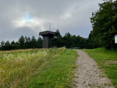
Route: The high point of Estonia is easily accessible and there is a car park and information board at the start point (see track). From there it is a simple walk up the road and turn left after a few minutes. Here you will see a rack of concrete steps that goes up to the rather imposing summit tower. You can climb to the top of the tower for a small fee but we didn’t as we were here early before it opened.
Route Statistics: An easy there and back 1.2km walk with 70m of height gain done in a sedate half hour.
Ascent Entry on Peakbagger: Suur Munamagi
GPX files: For gpx files click on the below.
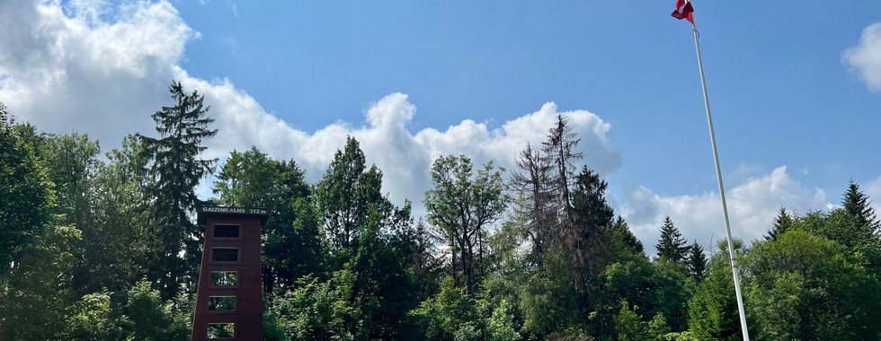
Gaiziņkalns
Information
The Gaising or Gaiziņkalns, at 312m above sea level, is the highest point in Latvia. It is situated in the Vidzeme Upland a short distance to the west of the town of Madona, central Vidzeme. Although only relatively low, Gaiziņkalns has been developed into a skiing area with three slopes and several guesthouses.
Summary
Baltic Tour Day 8. This was 390km day driving day from the University city of Tartu in Estonia to the castle town of Cesis in Latvia. On the way I learned from a smart arse that 55% of the roads in Latvia are gravel tracks. That’s over 11,000k’s worth of gravel and today we found at least 200 kilometres worth.
En route today we had a ‘look see’ at opulent Cesvain Palace before going on to hike…sorry…have a lazy amble up the highest point in Estonia (Suur Munamagi 318m) and Latvia (Gaizinkalns 311m). If both hikes had a combined height of over 100m I’d be lying but they all count. World Country High Points no’s 26 & 27 done.


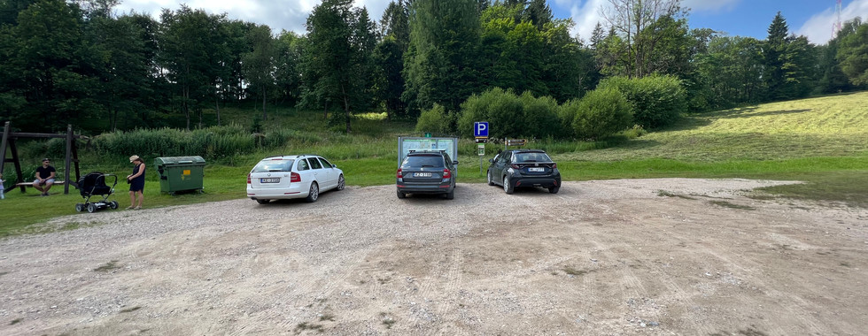
Location and route overview.


A few more pictures on this one.
Parking: Parking at start point.
Route: The high point of Latvia is easily accessible with a number of start points. There is a large car park at our designated start point (see track). From there it is a simple walk West up the grassy slope for a few hundred meters and turn left at the main track. Go another few hundred metres and the wooden non climbable tower of Gaizinkalns comes into view and shortly after you arrive.
Route Statistics: An easy there and back 1.2km walk with 70m of height gain done in a sedate forty minutes.
Ascent Entry on Peakbagger: Gaizinkalns
GPX files: For gpx files click on the below.
Aukštojas Hill
Information
Aukštojas Hill at 294m is the highest point in all of Lithuania; it is located in the Medininkai Highlands, Migūnai forestry, approximately 24 kilometres southeast of the capital city of Vilnius.
Summary
Baltic Tour Day 14. This was a short but busy 180km day taking in two UNESCO Struve Geodetic triangulation points and the highest point in Lithuania. The latter being Aukstojas at an altitude sapping 294m. Beautiful spot though and a nice viewing platform.
However….the highlight of the day was visiting the hill forts of Kernave. The forts are a UNESCO site and there are four of them together. What can I say, simply stunning…the best photos of the trip


Location and route overview.


Pictures of Aukstojas and Juozapine Kalnas.
Parking: Parking at start point.
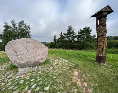
Route: The high point of Lithuania is easily accessible with a number of start points. There is a moderately sized car park at our designated start point (see track). From there it is a simple walk South along a track past a farm and you turn left shortly after (signpost). You walk East following the forest on your right and you soon come to the wooden viewing tour and the rock/boulder that marks the summit. All easy enough. We retraced our steps and went down to the track junction to bag nearby Juozapine Kalnas to as it is Lithuanias previous high point.
Route Statistics: An easy there and back 2km walk with 82m of height gain done in a sedate thirty minutes.
Ascent Entry on Peakbagger: Aukstojas
GPX files: For gpx files click on the below.


Comments