
No 20. Pic de Coma Pedrosa 2,943m, Andorra.
- dai186
- Nov 14, 2019
- 3 min read

Updated: Jun 23, 2022
12.9.2019 - Pico de Coma Pedrosa 2,943m. Sunny Andorra's highest point (UN Country High Point).
Information
Coma Pedrosa at 2,943m or 9,656 ft is the highest mountain in the principality of Andorra. It is popular with mountain climbers, its ascent being technically straightforward, although strenuous. From Arinsal to Camp de Refuge (650 m climb) is considered moderate meanwhile the last 862 m is considered to be difficult. Several mountain lakes and tarns are found on the slopes, notably Estanys de Baiau, which lies on the western slopes, across the Spanish border.
Summary
Nestled in the upper reaches of Andorra just above Arinsal is Pic de Coma Pedrosa. I had been looking forward to doing this peak for a while. I was also joined by a fellow Peakbagger friend from Samatan in France, David Guernot. I had stayed with Dave just the day before and we travelled up separately, he in his car and me in my motor home to stay in a campsite in La Masanna.
In the morning we drove up to Arinsal and got away at about 9am. It was a cracking weather day and a superb mountain lay ahead. We started at the municipal car park at Arinsal and went straight up the standard route up to the refuge. This took a couple of hard hours. We then followed the obvious gentle trail for a while amidst superb scenery and continued onwards and upwards to the two lakes. At one stage you start to head North to the lakes and it gets steeper again here. You pass both lakes on the right and a few hundred meters past the second one you will see a feint trail on the right that heads up the steep shale bank. This shale bank is not nice going and very steep, the steepest section of the day. However persevere as it brings you out to just below the summit.
Once on the summit the views are superb. We were able to linger for about 45 minutes in the sunshine before coming down the easier but steep ridge heading south until we rejoined the same path we came up on. Now this ridge is great, nowhere to exposed but a lovely ridge hike and scramble on occasions.
The route finding was all simple enough but it is a hard day with 15kms and 1,300m of ascent. Guide book and gpx files on the route does say 1,400m but my Garmin said 1,300m? We did it in 8hrs 30mins. Well outside the guide book time but we loitered a lot due to the superb views, having cameras and the perfect weather!
Nothing technical and the paths are good apart from the aforementioned shale bank which was steep, around 60%. It wasn’t possible to zig zag much on this section either but at the same time it wasn’t too loose.
All in all, a perfect mountain day!
Parking: There is a sizeable car park at the start point.
Route Summary: Stunning alpine peak on good well marked mountain trails. Very steep especially the shale section. Forest hike to start for 2-3 hours to the refuge. Rocky and steep overall with an excellent decent ridge hike/scramble.
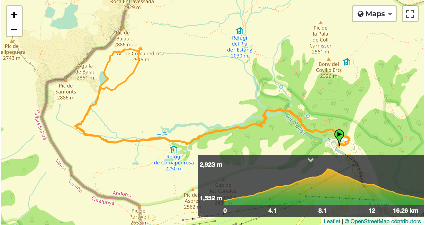
Route Statistics: 15kms with 1,300m of ascent done in 8hrs 30min.
Ascent Entry on Peakbagger: Pic de Coma Pedrosa
GPX files: For gpx files click on the below.
Interactive map from Peakbagger page.
Location and Route overview using Peakbagger.


Gallery


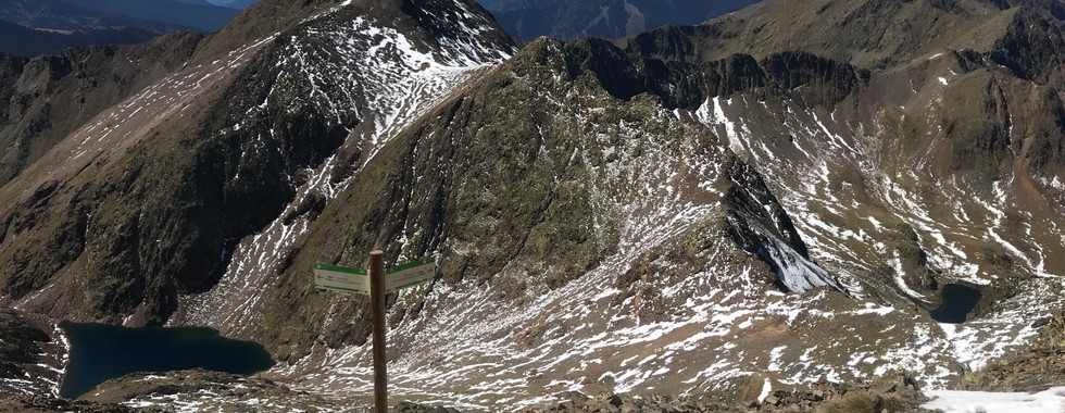


Stunning views on the way round.


Comments