
NW Trip No 5.Day.2 - Pen Yr Old Wen, Carnedd Dafydd, Foel Meirch, Carnedd Llewellyn and Yr Elen.
- dai186
- Sep 30, 2020
- 3 min read

Updated: Oct 3, 2020
17.9.2020 - Carneddau Loop, Ogwen Valley, Snowdonia, North Wales (5xNuttalls).
Pen yr Ole Wen 978m, Carnedd Dafydd 1,044m, Foel Meirch 800m, Carnedd Llewellyn 1,064m and Yr Elen 962m.
Anything in the Carneddau amounts to a pretty long day and today was no exception with a 21km big loop of the Carneddau on the itinerary. However the weather was breathtakingly clear and everything looked promising. Parking was again at the Gwern Gof Isaf campsite.
Heading West from the campsite there is an easy two km trail that takes you to the foot of Tryfan. Cross the road and slightly right is a signposted easy wide track that takes you up the Eastern flank of Pen Yr Ole Wen. It is a good path which literally follows the left bank of the river Lloer. It is a steepish pull with a couple of easy stream crossings (it has been dry however). After a km you cross over a wall via a style and veer left where a steeper rockier pull brings you to the top of your first Nuttall Pen Yr Ole Wen.
From the Wen head NE on an easy to follow path to Carnedd Dafydd for around 1.5km. Here are a couple of stone shelters should the weather be inclement for you. You could miss out the next bit if your not bagging Nuttalls really as the really rocky pretty pathless down and back journey to Foel Meirch is nothing to write home about. It is about 2km out and back with a 244m drop in height and due to the rocky terrain it is actually very slow going.
Back at Carnedd Dafydd you now take a long 2.5km North Easterly loop to Carnedd Llewelyn which is a lovely ridge hike with glorious all round views, simply stunning. There is another stone shelter here. Next is the 3km out and back leg to Yr Elen. Again you could miss this one out if you so wish but it is a really nice ridge hike out there and back and only a 100m of height loss with this detour. Again this is a rocky hike in places with some steep paths.
Back at Carnedd Llewellyn you now carry on heading downhill slightly South East towards Pen Yr Helgi Du. Again this is a lovely stretch of the hike and the views along Bwlch Eryl Farchog is stunning. As you approach it be careful as it gets really rocky and steep here as you start to drop into the Bwlch (pass). It is grade one scrambling country here and in the wet it will be slippery. This was the best part of the day for me and the views are superb.
Now in the ‘Bwlch’ you can either go up to Pen Yr Helgi Du which looks like a nice scramble or head off South in the middle of the Bwlch on a steep path that goes down fo Llugwy Reservoir. Seeing as I had done Helgi Du two days before there was nothing to gain and it had already been a long day so the reservoir route won the day. The route down from the col is steep and rocky and again in wet weather it will be obviously slippery. Once down the bottom however you have a kilometre on a path and two more on a tarmac road before your back at your start point. All in all, a stunning day out.
Parking: At Gwern Gof Isaf camp site. £2 per day or £8 per person stay.
Route Summary: Well trodden but rocky paths in the main, some easy grade 1 scrambling in places going down to Foel Meirch and at Bwlch Eryl Farchog. Long ascent up Pen Yr Ole Wen is your main lung buster of the day. Stunning views and an all round top hiking route.
Route Statistics: 21kms with 1,420m of height gain done in an all in time of 8 hours. Yes, it was very rocky and slow in places!
GPX files: For gpx files go to the Peakbagger website by following these links and go to the bottom right hand of the page and click ‘Download this GPS track as a GPX file.’
Ascent Entry on Peakbagger: Pen yr Ole Wen, Carnedd Dafydd, Foel Meirch, Carnedd Llewellyn 1,064m and Yr Elen.

OS Overview using ViewRanger.


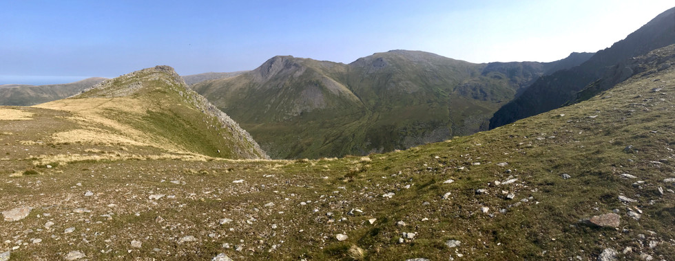


A selection of photos showing the stunning Ogwen Valley, Tryfan and the Carneddau mountains during a rare sky blue North Wales day.


Comments