
Waun Claerddu and Hafod Ithel, Two More West Wales Marilyns (Teifi Pools, Cambrian Mountains).
- dai186
- Mar 23, 2019
- 2 min read

Updated: Oct 3, 2020
21.3.2019 - Waun Claerddu 594m and Hafod Ithel 361m
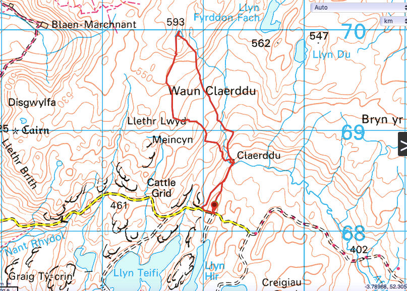
Waun Claerddu
Llan Ddu Fawr is the summit of Waen Claerddu in the Cambrian Mountains around the Teifi Pools area of West Wales about 15km North of Tregaron, Cardiganshire. It is a beautifully rugged area only accessible on an unclassified road from the village of Ffair Rhos. This narrow road takes you up dale down dale until you arrive just north of Llyn Teifi. Here there is a rough narrow track leading south down to the lake. You can park here where the track meets the road, there is only room for one vehicle.
From here follow my gpx trail north until you hit another rough track that leads you to an isolated remote bothy marked Claerddu on the map, one of the very few bothies in Wales. If you have a good 4x4 (Isuzu type) you could just about get to the bothy and indeed stay there for the night. There is fireplace, hard beds and the place is really cosy with an outside toilet.
From here uphill north west. You go up and down steadily and across some boggy water tables but nowhere too bad underfoot. Eventually after about 1.5kms you come over a brow and there is a trig point inset in a cairn. I turned round and came back on a slightly different route. There is no set path really apart from a few sheep trails. The views are nice though and the terrain remote and I just wish I had more time to make a longer hike out of it. There is a hike here that takes you around the nearby lakes for around 10-12kms. It is an area I will return too.
Route Summary: Beautiful rugged area punctuated by lakes and rolling hills, jurassic park type of terrain.
Route Statistics: 5kms done in 1hr 12mins with 221m of height gain.
GPX files:For gpx files go to the Peakbagger website by following this link and go to the bottom right hand of the page and click ‘Download this GPS track as a GPX file.’
Ascent Entry: Waun Claerddu
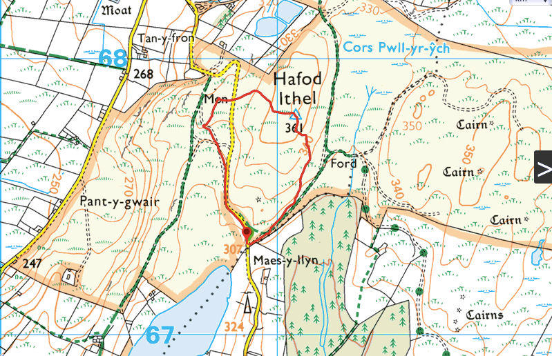
Hafod Ithel
Hafod Ithel is further to the West just north of Blaenpennal village. On the OS map the start is at the tip of Llyn Eiddwen. There is a track meeting the junction and there is room here for one or two vehicles at the most. This one is simple enough just follow my gpx trail north and uphill and you will soon get to the trig point after around half a km. From here I walked downhill and across the road to a small monument and came back to the start in a loop, albeit a small one.
Route Summary: Rolling hills and farmland, very pretty.
Route Statistics: 1.5km done in 20mins with 58m of height gain.
GPX files:For gpx files go to the Peakbagger website by following this link and go to the bottom right hand of the page and click ‘Download this GPS track as a GPX file.’
Ascent Entry: Hafod Ithel
Route overview using ViewRanger

Parking spot at the start. Room for one vehicle only. Teifi lake in the background.

The bothy at Claerddu.

Cosy.

One of the 3/4 sleeping areas.

Rolling Welsh countryside.

The trig point at Waun Claerddu.
Overview using ViewRanger.

Summit trig point with.

Nearby monument.


Comments