
High Willhays and Yes Tor, Dartmoor's Nuttall High Points.
- dai186
- May 12, 2021
- 2 min read

30.4.2021 - Day 3.
Yes Tor 619m and High Willhays 621m, Dartmoor (Nuttalls).
Summary
A glorious sky blue day taking in the only two Nuttalls South of the Brecon Beacons. Yes Tor 619m and High WillHays 621m. The latter also being a county high point, a national park high point, a Marilyn and a Hewitt...so so good for my peak lists! The light enhanced the pictures tenfold today and really brought out the raw beauty of this rugged national park. A wonderful wonderful day!
The route started at a friend’s house which sits near Oakhampton military camp and therefore it is right on the edge of the moor. The route took me on the road South and then across country on good trails to Row Tor then West Mill Tor and onwards and upwards to the impressive rocky outcrop of Yes Tor. The views were great on the way and Yes Tor is a brilliant vantage point and rest stop. It is just over 4km to here.
After Yes Tor I kept heading South for an undulating kilometre to High Willhays’ rocky cairn. The height loss is minimal here, just about enough to classify both summits as Nuttalls. I kept heading South here to take in the rocky knoll of Dinger Tor before heading NW to take in Fordsland Ledge and Black Tor before heading due North to the cairn at Longstone Hill. There are great views here looking over the Okement valley.
As rain was in the air I decided instead of dropping down to Meldon Reservoir and walking back via Okehampton I would cut across country East keeping high. I dropped down NE to Red a ven Brook and then climbed up the other side. It was all on good paths as I continued to Black Down. The paths are actually excellent and it wasn’t long until I picked up a wide trackway that took me back onto the tarmac road that led me back to the start point. An excellent outing!
Parking: There are ample pull ins/parking areas around the start point near the camp.
Route: Excellent paths in the main, some cross country hiking which was not too difficult, tracks and tarmac road. Great views and some impressive rocky hilltop knolls. Raw and rugged countryside.
Route Statistics: 16km 550m height gain day in an all in time of 4hrs 51mins.
Gpx File:

Route overview using ViewRanger.


Views from the start point along to Row Tor and West Mill Tor.


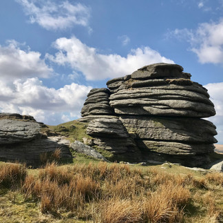


Views on the way up to Yes Tor and the Trig Point.


Views across to and from High Willhays cairned summit.


Views from Black Tor.


Some pictures from the Northern end of the route.


Comments