Peak & Lake District Sojourn. Day 21.
- dai186
- Jun 16, 2021
- 3 min read
Loweswater Fells Loop (5xWainwrights). Burnbank Fell 475m, Blake Fell 573m, Gavel Fell 526m, Hen Comb 509m and Mellbreak 512m. Stuart Marshal Route No 34.
Summary
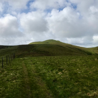
Well I think if I stay here long enough I might get a proper blue sky day but today again was not that day. However a great route around five Wainwrights near Loweswater lake in the Western Fells. Not that high, in fact none of them are over 600m but this is a world class hike. Plenty of stiff ups and downs and the views from the tops were stupendous especially from the last Wainwright, Mellbreak. Absolutely gorgeous views looking down on Crummock Water and down over Loweswater Lake. Top top day.
Parking was off the back road near Loweswater at Maggie’s Bridge car park. Enough room for about 10 cars but there are trees, a narrow access road and it is a bit tight for turning. Maximum vehicle size would be a VW camper van. There are also two ports loos. When your ready head out on the wide track towards Loweswater Lake and you will come to a foot gate going into Holme Wood. Follow the path up through the wood and you come out by Holme Beck. Look upstream and you will see a visible fence that goes straight up the flank of Burnbank Fell. I mean straight up it! Go up it and you come out on the NE slope of Burnbank. Walk SW for 500m to the small cairn at the summit.
Next you head directly South, down hill, following a fence and then up to Blake Fell. The same again goes for Gavel Fell. Pretty decent climbs too. You then keep following the fence South but then branch off to the left to cut a corner off. Your heading for a distance fence line. You don’t have to cut the corner off but it saves a bit of distance, the going is off piste but okay. Once you hit the fence you head East and then steeply up to Hen Comb. This is quite a stiff climb.
You have already done around 700m of ascent and 10km of hiking by here but the next leg is the hardest. Mellbreak looks like a beached whale on the the other side of the valley and you head down hill very steeply over a heather covered slope towards another fence line. The gradient is around 40% but the heather made it easy underground as it gave purchase and was not deep. Once at Mossdale Beck you cross it and climb up to the obvious footpath. There was quite a bit of ferns here but not too tall in June. Once at the footpath you go steeply uphill once again and veer off to the right on another footpath that takes you to Mellbreak’s 512m top. There are great views from here.
You now retrace your steps and carry on steadily uphill North to Mellbreak’s North top. Again there are more stunning views.
The last decent of the day is on a narrow rocky footpath and yes, it goes down very steeply zig zagging as it goes. Towards the end the rocks are loose and you have quite a bit of scree. Watch your footing but I have come across much worse. Once at the bottom there is an obvious path that takes you North back into Loweswater where you hang a left and then left again to walk down the short distance to your start point. A great hike!
Parking: Small car park at the start point. Restricted access and turning for large vehicles.
Route: Good footpaths, a bit of cross country here and there, some boggy ground but not much and a steep rocky decent coming off Mellbreak with a finale of scree to finish it off. This is a good hiking route with lots of ups and downs but all the views are worth it. Cairns on all the summits.
Route Statistics: A decent 15km done with a hard 1,110m of ascent in 5 hours.
Info sheets.
Burnbank Fell
Blake Fell
Gavel Fell
Hen Comb
Mellbreak


Comments